Highway of Hegemony: G216 Serves Beijing’s Expansionist Ambitions
China is on the verge of completing the G216 Highway near its contested border with India after suffering casualties in the Galwan Valley clash with the Indian Army in 2020. The Chinese leadership has long dreamed of the G216. Mao Zedong was eager to connect Tibet and Sinkiang (present-day Xinjiang), two newly conquered regions, in early 1951. Finding a link between Xinjiang and Tibet was a national priority because the Uyghurs’ territory had been taken in December 1949 and western Tibet had been attacked in November 1950.
In 1951 when the PLA decided to cross the massive ‘Kunlun’ mountain ranges along the Keriya ancient road in Hotan county ,it encountered the massive volcano of Ashi Tan where many road workers were killed and hence the plan to build an alternative route through the Keriya route was shelved and this is how the G219 national highway came into existence. However, Chinese leaders never lose sight of their forebears’ aspirations. The establishment of a new connection between Xinjiang and Tibet i.e G216 is currently one of President Xi Jinping’s most secret initiatives.
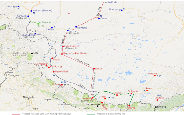
As per ‘National highway network planning’ (2013-2030) the G-216 runs from Hongshanzui port ( Altai county, north of Xinjiang Uyghur autonomous region or XUAR) in the direction of Baluntai in Hejing county ,where it joins China national highway G-218 ,then moves on to Luntai county entering the Taklimakan desert till Menfeng county. It then proceeds to Garze County in Tibet to finally join Kyirong near Nepal border.
The G-216 national highway is 857 kilometers with Tibet’s section alone about 558 km. China has made significant investments in Tibet alone, totalling more than 6 billion RMB (more than $1 billion USD), and funding provided by the production corps and regional authorities of Xinjiang served as a vital support system for building. For several important road projects in Xinjiang, including portions of G216, more than 9.5 billion RMB was allotted.
China’s G-216 Highway construction poses considerable geological and ecological risks, especially given its route through some of the world’s harshest environments. The Taklamakan Desert, the Kunlun Mountains, and Tibet’s extremely delicate Changthang National Nature Reserve are just a few of the varied and delicate ecosystems that the highway passes through. Concerns are raised over the destruction of distinctive alpine ecosystems and the disturbance of habitats for endangered animals.
China has speeded up the construction activity on this G-216 national highway after May 2020 Galwan valley clashes with Indian army. For containment of India and speeding up its force levels all along the Ladakh frontier as well as the middle sector, China doesn’t have to depend solely upon G-219 national highway to switch forces inter sector or intra sector, since it will now use the under construction G-216 National highway to bring to bear its max number of forces for a decisive action.
The impact of China’s G216 highway extension will be mitigated by India’s new 130-kilometer alternate road to Daulat Beg Oldie (DBO) in Ladakh, which offers a quicker, safer, and less exposed path for supply and military mobility. The new road, which passes through Sasoma, Saser La, Saser Brangsa, and Gapshan, avoids direct Chinese monitoring, in contrast to the current Darbuk-Shyok-DBO (DSDBO) road, which travels along the Line of Actual Control (LAC) and is subject to Chinese surveillance.
This new Sasoma–Saser–Gapshan road shortens the distance from Leh to DBO by 79 km and cuts travel time from two days to about 11-12 hours. The road supports heavy military vehicles and artillery, including Bofors guns, through upgraded bridges with 70-tonne load capacity, enhancing India’s offensive and defensive capabilities in the region. It also supports the Siachen base camp for soldier acclimatization and operational readiness. Overall, this alternate route blunts the strategic advantage China hopes to gain from G216 by securing India’s mobility, logistical resilience, and operational flexibility in the contested Ladakh border region.
China’s G-216 Highway is a transformative infrastructure project with far-reaching implications for regional connectivity, local economies, environmental management, and Sino-Indian border dynamics. India must remain vigilant regarding China’s nearly complete G216 Highway, a long-standing strategic project connecting Xinjiang and Tibet through harsh terrain. This strategic infrastructure duel underscores the need for India to continually strengthen its border connectivity and military logistics to maintain operational flexibility and deter potential aggression effectively.